- Interview with the Winner of the ESA-EGU EO Excellence Award 2021 | AZO – Space of Innovation
Maryam Pourshamsi, Earth Observation Scientist at European Space Agency (ESA), interviews Luca Brocca, Director of Research, National Research Council/Research Institute for Geo-Hydrological Protection, PhD.
- Webinar of Luca Brocca on Soil moisture, a key variable for hydrological prediction: flood, landslide and drought
On 15 June 2020, Luca Brocca was invited to held a webinar by Cátedra UNESCO-IMTA “El Agua en la Sociedad del Conocimiento” to talk about “Soil moisture, a key variable for hydrological prediction: flood, landslide, drought and SM2RAIN”. If you missed it and you wish to watch it click on the video:
- Webinar of Christian Massari on The added value of satellite observations for modeling and monitoring floods and droughts: insights and open issues
On 17 June 2020, Christian Massari was invited to held a webinar by Cátedra UNESCO-IMTA “El Agua en la Sociedad del Conocimiento” to talk about “The added value of satellite observations for modeling and monitoring floods and droughts: insights and open issues”. If you missed it and you wish to watch it click on the video:
- Webinar of Angelica Tarpanelli on the “Multi-mission satellite observations for river discharge estimation”
On 18 June 2020, Angelica Tarpanelli was invited to held a webinar by Cátedra UNESCO-IMTA “El Agua en la Sociedad del Conocimiento” to talk about “Multi-mission satellite observations for river discharge estimation”. If you missed it and you wish to watch it click on the video:
For @ESA FDR4ALT project #altimetry high-res products will be reprocessed with global coverage to provide users with a consistent water level data record for #rivers #lakes #reservoirs #wetlands
For a fit-for-purpose product ?help us filling the surveyhttps://t.co/qs4a70TPJj pic.twitter.com/FqPrqTNRFe— Hydrology IRPI-CNR (@Hydrology_IRPI) 14 novembre 2019
- We are glad to announce the 6th Satellite Soil Moisture and Application Workshop that will be held in Perugia in September 2020 with the purpose of discuss and reconcile recent methodological advances in the development, validation and application of global satellite soil moisture observations.Further details can be found here: http://www.irpi.cnr.it/conference/the-6th-satellite-soil-moisture-validation-and-application-workshop/
- We are hiring one new research fellowship for working in the OT4CLIMA project that intends to develop advanced Earth Observation (EO) technologies and methodologies for implementing innovative applications & products capable of responding to the major social challenges posed by climate change (flood, landslide and drought).Further details can be found here: https://bandi.urp.cnr.it/doc-assegni/documentazione/8799_DOC_IT.pdfThe deadline for applications is May 31st, 2019. For non-Italian speakers please go through the pages of the documents to find appropriate forms in English. In case of any doubt or clarification please contact luca.brocca@irpi.cnr.it
- The Hydrology Group of Irpi-Cnr wins the BayWa Smart Farming Challenge
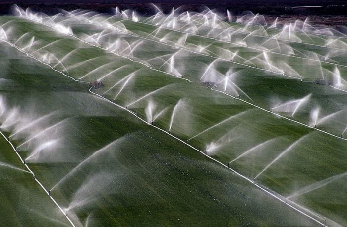
The Hydrology Group of Research Institute for Geo-Hydrological Protection (IRPI) from the National Research Council, Italy, has won the “BayWa Smart Farming Challenge” as part of the International Copernicus Masters competition. By using Copernicus Sentinel-1 and -2 satellites, the Hydrology Group at IRPI developed an algorithm to provide estimates of water used for irrigation every day at the field scale. “Around 70 percent of the world’s available water is used for agriculture”, says Luca Brocca, researcher of the Hydrology Group at IRPI. “We were previously limited in our ability to precisely determine the global water consumption and intervene accordingly – not just technically with the use of appropriate monitoring programmes, but also where water was available free of charge or withdrawn illegally. Satellite data helps us overcome these hurdles – this is a ground-breaking innovation for agricultural and food production.”
The very exciting time of our award ?at #CopernicusMaster 2018
More info here: https://t.co/tvAzTuIOAb@BayWaPresse @CopernicusEMC @CopernicusEU @StampaCnr pic.twitter.com/Z70M5V7PFk— Hydrology IRPI-CNR (@Hydrology_IRPI) 7 dicembre 2018
- IRPI Hydrology Group to the International Remote Sensing School for Hydrological Applications 2018
In the context of the H SAF project funded by EUMETSAT, the Italian Civil Protection Department in close
collaboration with the Italian Air Force Meteorological Service Department, IRPI-CNR Hydrology Group, Cima Foundation, ECMWF and the Technical University of Vienna has organised the International Remote Sensing School for Hydrological Applications 2018. The course has been held from 13 to 16 November at Casa dell’Aviatore in Rome. The course has been addressed to students and professionals from all over the world and focuses on the use of satellite data of soil moisture for hydrological applications and for the mitigation of the natural hazards.
Very nice experience and atmosphere @eumetsat #HSAF school on ?️#soilmoisture 4 hydrological applications
thanks to all trainees ?@ESA_EO @CopernicusEU @WMO @CIMAFoundation @DPCgov @ItalianAirForce @CNRDTA pic.twitter.com/Umf73ngTBO— Hydrology IRPI-CNR (@Hydrology_IRPI) 16 novembre 2018
- How much water is used for irrigation?
See our Youtube video that we have prepared for the ESA Phi-Week (12-16 November) showing our idea for using remote sensing for irrigation. Sentinel-1 and -2 satellites will provide high resolution estimates at field scale, useful for companies, farmers, and national agencies involved in agricultural water management.
- River discharge assessment through the use of optical and altimetry satellite data
A second Youtube video that we have prepared for the ESA Phi-Week (12-16 November) showing how to estimate River discharge from space. Satellite data from altimeter and optical sensors are combined to monitor the flow of the river also for ungauged or poorly gauged basins. The proposed approaches can be useful for water resource management, flood forecasting and for hydraulic risk mitigation.
- IRPI Hydrology Group as a finalist of the Copernicus MasterHydrology group is one of the top three finalists of the International Copernicus Master Competition for the “BayWa Smart Farming Challenge” addressed to innovative solutions that use new technologies, ideas and products to support sustainable agriculture. More information on the BayWa website and Twitter.
- Angelica Tarpanelli interview for ESA Space in Videos
During the 25 Years of Progress in Radar Altimetry Symposium, Angelica Tarpanelli, researcher at IRPI was interviewed by the European Space Agency to talk about river discharge, its importance in the hydrological cycle and its influence with the sea level change.
- Luca Brocca interview on economiacristiana.it to talk about the use of satellite to detect how much water is used for irrigation
The 25th of September 2018, Luca Brocca released an interview for economiacristiana.it (ITA) speaking about the recent research on the water quantification for crop irrigation.
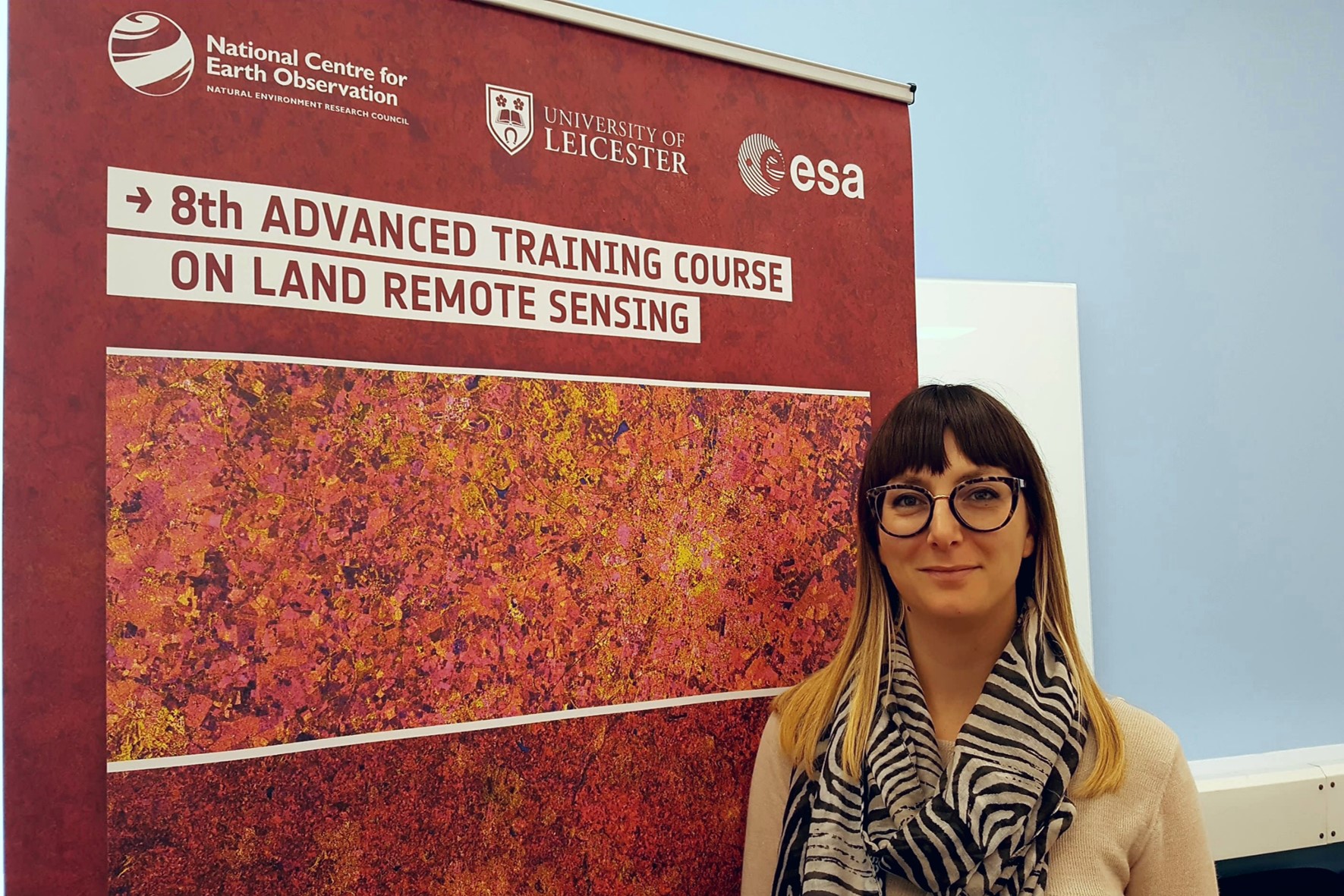
- Angelica Tarpanelli presents a lecture at the Land Remote Sensing Advances Course
Angelica Tarpanelli, researcher at IRPI-CNR in Perugia, contributed to the 8th ESA Land Remote Sensing Advanced Course 2018 with a lecture entitled: “River Discharge and Lake Volume Variation using Radar Altimetry and Imaging Sensors”. The course is organized by the European Space Agency and is held at the University of Leicester, UK from 10 to 14 September 2018. The aim of the course is training the next generation of Earth Observation (EO) scientists to exploit data from EO missions for science and applications development.
- Christian Massari on RAISCUOLA to talk of SM2RAIN and the real time flood forecasting (ITA)
Tra i protagonisti del programma in onda su Rai Scuola anche i ricercatori del CNR-IRPI di Perugia.
La puntata “Umbria – Un viaggio alla scoperta dell’Italia della ricerca e della sperimentazione scientifica” è stata trasmessa martedì 6 giugno alle 21.30. Christian Massari (dal minuto 22:35) ha spiegato al pubblico alcune fra le tematiche di ricerca affrontate dal gruppo di ricerca. In particolare ha illustrato le attività connesse al monitoraggio e alla previsione delle inondazioni.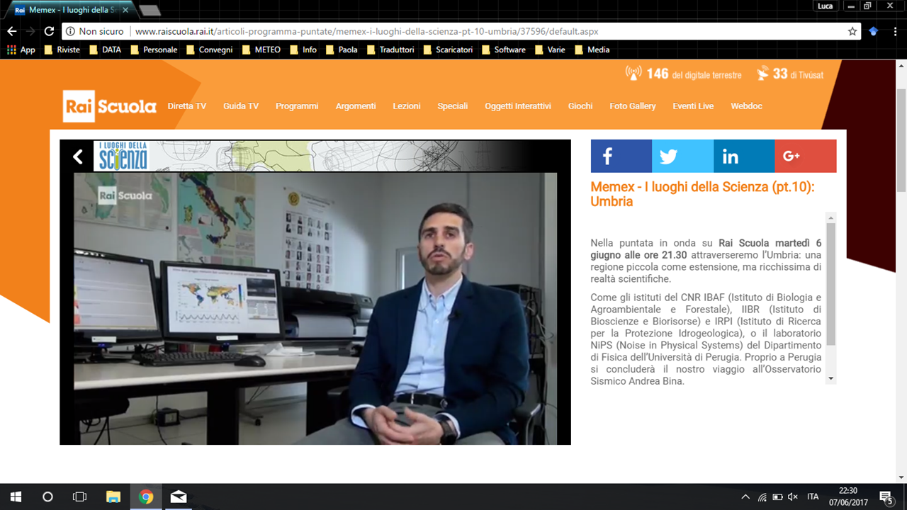
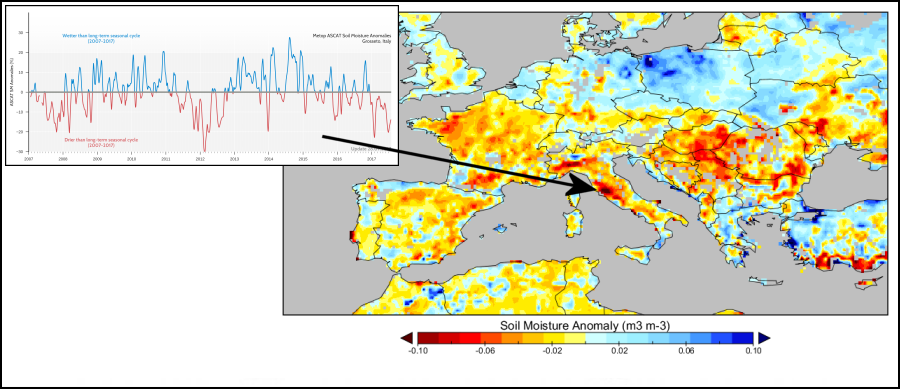
- We do see Drought from Space
A long-term global satellite soil moisture dataset now allows IRPI-CNR to closely monitor and predict drought situation.