SaTellite based Runoff Evaluation And Mapping
ESA Contract No. 4000126745/19/I-NB
Period: 2019 – 2020 (12 months)
Partners: The consortium is based on a close collaboration between 2 partners:
- IRPI CNR: Istituto di Ricerca per la Protezione Idrogeologica (Prime contractor)
- Institute of Geodesy at the University of Stuttgart (https://www.gis.uni-stuttgart.de/, GIS, Subcontractor)
Description: Water is at the centre of economic and social development; it is vital to maintain health, grow food, manage the environment, and create jobs. As well over half of the world’s potable water supply is extracted from rivers, either directly or from reservoirs, understanding the variability of the stored water on and below landmasses, i.e., total runoff, is of primary importance. In situ observations or land surface/hydrological models are generally used for the quantification of total runoff but they suffer from many limitations. Developing innovative methods able to maximize the recovery of information on runoff contained in current satellite observations of climatic and environmental variables becomes mandatory and urgent. STREAM project will develop a conceptual hydrological model for deriving runoff estimates from satellite soil moisture, precipitation and terrestrial water storage anomalies. The underlying assumptions behind STREAM are the knowledge of the key mechanisms and processes that act in the formation of runoff like the role of the soil moisture in determining the response of the catchment to the precipitation inputs, which have been soundly demonstrated in more than ten years of literature studies.
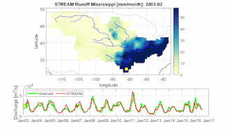
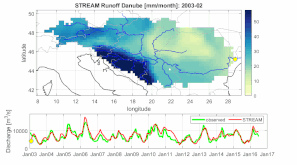
Main results: A simple and versatile conceptual hydrological model, STREAM, has been developed during the 1-year ESA project. The model was able to accurately estimate river discharge and runoff over 5 pilot basins across the world (Mississippi, Amazon, Danube, Murray-Darling and Niger) by using satellite observations of precipitation, soil moisture and terrestrial water storages. As an example, the animation in the following represent the simulated runoff map and the monthly observed/simulated river discharge data at the outlet section of the Mississippi (first animation) and Danube (second animation) river basins.
Despite the good results obtained, for specific case studies (such as for basins with high human impact or for highly vegetated areas) STREAM model was found to fail the objective of accurately reproduce the observed river discharge. The possibility both to improve the model and to complement the model with a different satellite approach for river discharge estimation (RIDESAT) will be explored in the ESA STREAMRIDE CCN project .
 |
 |
Publications:
1. Camici, S., Giuliani, G., Brocca, L., Massari, C., Tarpanelli, A., Farahani, H. H., … & Benveniste, J. (2021). Synergy between satellite observations of soil moisture and water storage anomalies for global runoff estimation. Geoscientific Model Development Discussions, 1-38. https://doi.org/10.5194/gmd-2020-399.